


DANVRAI22 16:52:58

UDGI54
User
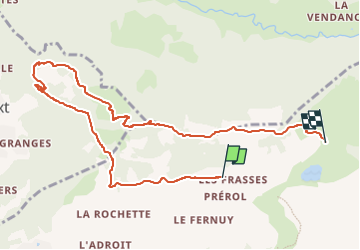

Length
9.9 km

Max alt
1715 m

Uphill gradient
513 m
Km-Effort
16.7 km

Min alt
1357 m

Downhill gradient
483 m
Boucle
No
Creation date :
2022-12-06 16:03:55.534
Updated on :
2022-12-06 16:03:55.534

FREE GPS app for hiking
 SityTrail
IGN / Geographical institutes
SityTrail Plus
The world is yours!
About
Trail of 9.9 km to be discovered at Auvergne-Rhône-Alpes, Upper Savoy, La Clusaz. This trail is proposed by UDGI54.
Positioning
Country:
France
Region :
Auvergne-Rhône-Alpes
Department/Province :
Upper Savoy
Municipality :
La Clusaz
Location:
Unknown
Start:(Dec)
Start:(UTM)
303067 ; 5087797 (32T) N.
Comments